 www.geodatenkatalog.de (S2L)
Keyword
Ellesmere Island
2 record(s)
Provided by
Type of resources
Topics
Keywords
Contact for the resource
-
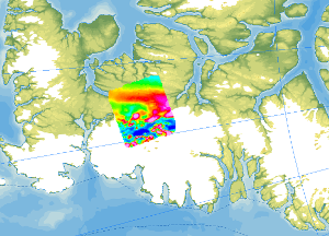
As part of the CASE 12 expedition, geological fieldwork and an aeromagnetic survey were conducted on Ellesmere Island (Canadian Arctic) in the summer of 2011. The helicopter-borne magnetic survey covered the ice-free areas between Vendom Fiord and Strathcona Fiord in the west and the ice-covered mountain ranges of the Inglefield Uplift in the east. With a total flight time of approx. 35 hours, 4200 line kilometres were flown covering a total area of 6000 km². The distance between the individual lines was 2 km, and control profiles perpendicular to the individual lines were flown every 10 km. The aeromagnetic data were recorded by a magnetometer, which was towed approx. 30 m beneath the helicopter.
-
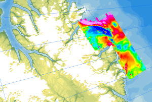
Onshore geological field work combined with an onshore/offshore aeromagnetic survey was carried out during a joint expedition of the German BGR and the Canadian GSC to understand the structural architecture of the North American continental margin. The helicopter-borne magnetic survey of 2008 covered the northern coastal areas of Ellesmere Island and the adjacent marine areas. The survey was conducted with a line separation of 2 km and covered a 40 to 50 km wide swath offshore about parallel to the north coast of Ellesmere Island from Yelverton Bay in the west to Parr Bay east of Cape Columbia, the northernmost point of Canada. Between Yelverton Bay and M'Clintock Inlet, the survey extended about 40 to 50 km inland, which was the prime target area of the CASE 11 geological investigations. This section of mountainous terrain was flown in a “draped” mode to keep the distance to ground at approximately 1500 ft, same as over the offshore areas. During a 4-weeks period in May/June 2008, close to 8000 km of aeromagnetic line data were acquired, covering an area of 12000 km².